
This website was created in May 2009.
The content below is from the site's 2009 - 2011 archived pages.
The new site's owner is no longer accepting articles for canberrahistorygroup.com.
The Canberra History Group's Aim
Our history group will endeavour to cover items we hope will be of interest for all types of historians - local history, family history or general history - especially unusual items, or those that may not be easily accessible, or taken from local knowledge that has been either passed down, or we have experienced ourselves, since we've lived or were born here before the 1950s!
We are only a small group of dedicated compilers and researchers and welcome contributors with similar interests in the history of Canberra. Our CONVICT pages, it is hoped, will contain biographical material about the convicts who lived on or around the Limestone Plains. If you are related to anyone mentioned in our lists, please let us know. You're especially welcome if you wish to contribute a small biography of your convict ancestor.
Our ARTICLES page also includes some interesting ESSAYS regarding particular subjects relating to an earlier Canberra, including STIRLING PARK, originally called WESTLAKE, now part of the suburb of Yarralumla. This area included one of the largest camps for Canberra's early construction workers. Before that, it was, and still is, of great significance to Canberra's Aboriginal people. Read Ann Gugler's articles to find out why!
Our page on INQUESTS-OBITUARIES, also include Court Cases, and bits of trivia we have located while researching other material. They mainly concern people who once lived in the Canberra district and provide an excellent insight into early Canberra history. This will be an on-going page.
We also have a PHOTO GALLERY, containing both old and new photos of various parts of Canberra, including some relating to the 2003 Canberra Firestorm - Mt. Stromlo, Narrabundah Hill and Duffy. The photograph, used as our Logo, was taken in 1999 of the Wood's family hut at Paddy's River, Tidbinbilla. Unfortunately, it was lost in the Firestorm.
Some of us have written books and these are found on our PUBLICATIONS page.
If you are interested in the history of Canberra and district, or have old family links to the area, you are welcome to join us and contribute articles on this new website! And don't forget, we have a GUESTBOOK for you to sign and let us know your thoughts about our website.
Enjoy!
Trish Frei
for The Canberra History Group
Note: 'The District' means all of the Australian Capital Territory; all parts between and including Queanbeyan, Bungendore, Lake George, Captain's Flat NSW, north to Gundaroo and south to around Bredbo.
The Convicts pages, at present, reflect only the major or well-known landholders who included properties within the Canberra to Queanbeyan-Bungendore region in their land holdings.
The first time I visited Canberra was when I was sent to bring a client up to date on the newest rollout from Salesforce: Their Community Cloud, that allows businesses and organizations to connect employees, customers, and partners all in one (branded) space. The possibilities are endless and I had been dispatched to Australia's capital city, Canberra as part of a Salesforce Community Cloud consulting team. For 21,000 years the Canberra region has been home to the Ngunnawal people. Evidence of their long occupation exists in archeological evidence at numerous places throughout the Australian Capital Territory (ACT). Aside from working with my client to make sure we were following the best proper strategy, development and implementation of Salesforce Communities, I spent all my free time learning more about the Tidbinbilla Nature Reserve and the Namadgi National Park. I had requested a two week vacation after I finished my Salesforce consulting and implementation specifically to visit the Tidbinbilla Nature Reserve and the Namadgi National Park. I wanted to discover more about the park's Aboriginal heritage, as well as experience its wonderful bird life, get several days of fishing, and enjoy some bush walks, which I was told ,would afford me many incredible scenic views. In addition I spent several sight seeing days in Canberra which has it's own fascinating as the content below shows.
Canberra History Web
(Formerly 'The Canberra History Group')
Sorry, personal family history research queries are not undertaken.
The Tagline
'For here have we no continuing city...' is a 'prophetic message' engraved on Sarah Webb's gravestone in the churchyard of St. John's, Reid ACT. Sarah died on 8 November 1845, aged 33, and was the 5th person to be buried in the churchyard. She and her family were pioneers of the Limestone Plains at a time when Canberra was a rural district.
In 1845, no-one thought of a city in the area. It took the Federation of Australia in 1901, and a later Federal Government decision to decide that the home of the district's pioneers should become the site for the new national capital of Australia - to be known as 'Canberra' [pronounced 'Canbra', with the emphasis on the 'Can'!] Canberra was a planned city, built from the ground upwards, once the sheep were removed. They were still happily grazing in the centre of the growing city in the 1950s and into the early 1960s until new buildings finally forced them out.
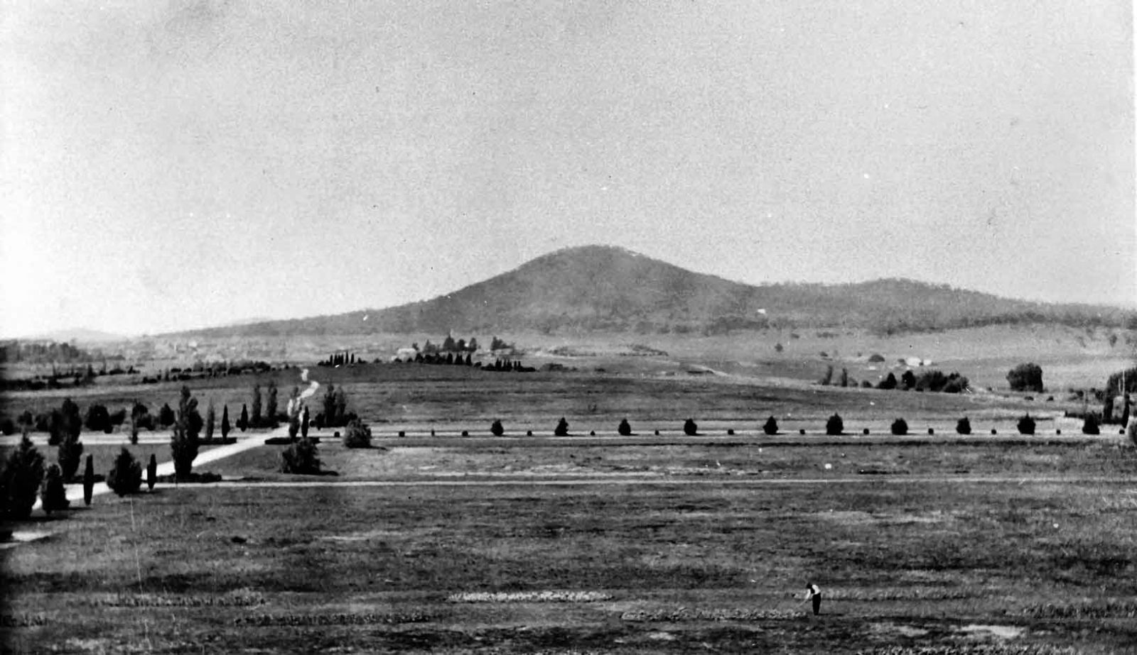
The Limestone Plains - i.e. Canberra - 1923
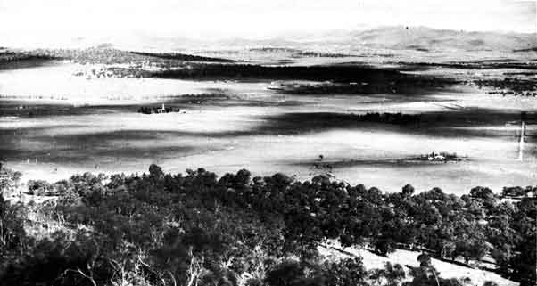
The Limestone Plains in 1923 from Mt. Ainslie - St. John's church is centre left, surrounded by trees. You can see the steeple jutting out into the landscape.
Canberra - April 1910
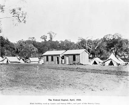
The first Surveyor's Camp and buildings in Canberra - the Lands and Survey Office and Camp, headed by Charles Scrivener.
Laying the Foundation Stone - 12 March 1913
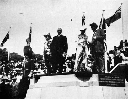
Above: 12 March 1913 - the Laying of the Foundation Stone of Canberra. From left: Lord Denman, Governor-General; Andrew Fisher; Lady Denman; King O'Malley, Minister for Home Affairs; Lady Denman is about to read the card bearing the name of the new city, which she pronounced with the accent on the last syllable, as 'Canbra', and not 'Canberra'.
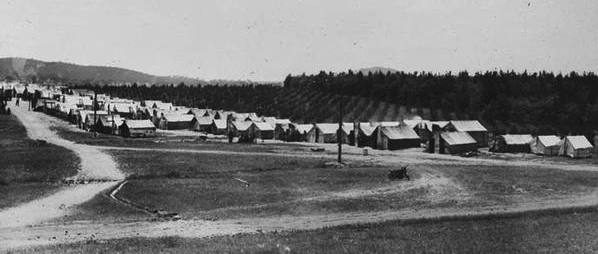
Camps, humpies, & timber buildings - Yes, this was Canberra!
The disintegration of a landed society began as the Federal Government resumed freehold grazing land for the future city and its suburbs. Farmers could lease land until required by the government, leave the district with a small compensation packet, or join the growing workforce.
Construction workers began to arrive c1913 to build the new city - but they had to build the infrastructure first: the Cotter Dam to contain water; the sewerage system at Weston Creek; the roads - as well as the provisional Parliament House and other Administration buildings - all temporary buildings, which were slowly being constructed. Accommodation was temporary as well, with most workers being in camps of tents or humpies to begin with. These lasted a number of years and they were freezing cold in the winter months, with barely any heating, and some with none at all. Barrack style army huts eventually arrived with mess halls and these became hostels for construction workers, and later for government servants, who arrived to administer both Canberra and the Federal Government. Ann Gugler takes you on an adventure through some of the camps - see our ARTICLES page.
In the 1950s it was thought that Canberra was a good sheep paddock gone to waste - and some older residents still think so today. Suburbs since the 1960s have encroached upon many rural land leases to a greater extent than previously, and continue to do so, with the land continually being resumed for suburbs to take an ever increasing population. But we are still called the bush capital, due to the surrounding area, which is still bush, or grazing land, until it too, is resumed for yet more suburbs.
Canberra's centenary is around the corner, in 2013. But what was there before, on the Limestone Plains, pre 1913, the year Canberra was declared a 'city'? And what happened after 1913, when all the infrastructure required for the new city of Canberra had to be built from the ground up?
We will try to provide an insight into Canberra's pre-history, using various data available to us, and wherever possible, sources and references will be stated, so you can follow up further information yourself.
Above: The Sewer Camp, Westbourne Woods, now part of the suburb of Yarralumla, 1920s. The camp composed of construction workers working on the sewerage tunnel, which led from the provisional Parliament House, through Yarralumla, to Weston Creek. It is still there today. Sewer vents can be seen in Stirling Park and opposite the RSPCA, Cotter Road. The one below is in Stirling Park, Yarralumla, in an area that used to accommodate some 700 people and was called, Westlake.
Canberra - 1909 and 1927
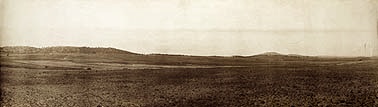
Above: The desolate, treeless, Limestone Plains, 1909. The area is now part of central Canberra - and filled by Lake Burley Griffin!
Below: Canberra, towards Mt Ainslie, 1927 [Jones Archive]
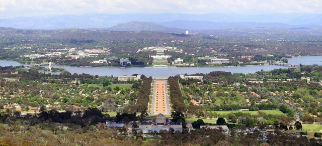
Canberra from Mt. Ainslie - 2005
Showing the Australian War Memorial, Anzac Parade, Lake Burley Griffin, old and new Parliament House. The suburb of Campbell is on the left, and Reid is on the right of Anzac Parade.
Convicts - Canberra and District
The Canberra District includes: the area in between Gundaroo (north), Bungendore/Lake George/Lake Bathurst (east), south to the Monaro (for reasons spelt out below), Queanbeyan, and west to the Brindabella Ranges. It may include some regions beyond these boundaries, due to landholders occupying land in those regions. It does not include Goulburn or Braidwood, where these towns are specifically identified.
The list includes: known assignees to the Canberra district that gained a Ticket-of-leave, Free Report, Passport, a Pardon, in Queanbeyan NSW, or were Free by Servitude within the area. The 1828 Census designates some people as FREE, but since they arrived on a convict ship, they have been included until research proves otherwise. A ‘F’ or ‘CF’ has been placed next to their name since their sentence may have expired by the time they were employed in the district. Basically, if they were in the district at any point in time, then they are included here, until proved otherwise, in which case they will be removed!
Various names were used for Canberra and the surrounding district in the 1828 Census. The name ‘Goulburn Plains’ can include Burra, Bywong, Canbury (Canberra), Gundaroo, Limestone Plains (Canberra), Gingira (Jingera), Gunning, Michalago (Michelago), Molonglo, Murrumbateman, Murrumbidgee, Tarago, Yass and Yass Plains. ‘Maneroo’ (Monaro/Monaroo) can also mean those places including and south of the Limestone Plains (Canberra).
The benefit of doubt has been taken with convicts who resided on the ‘Goulburn Plains’, ‘Yass’ or ‘Maneroo’. Many were employed by known local district landholders who may have deployed their labourers on other acreages they held in the region as watchmen/shepherds/hutkeepers attending stock.
Robert Campbell of Duntroon was often described in the 1828 Census as ‘R. (or Robt.) Campbell, Limestone Plains, Goulburn Plains’. John Palmer of Ginninderra was likewise. In these cases only ‘LP’ has been used.
If you are descended from a convict listed on this website, or know of one we may have missed – your contribution would be gratefully accepted. If they did NOT receive a Ticket of Leave, Passport, or Pardon from the area mentioned above, they will not be included.
All ships have been checked with, and names corrected, using Bateson and/or other available shipping records as noted in the ‘Key – Sources’, including the Sydney Gazette.